Sunday afternoons on the Jordan River Trail with the kids. Bikes, scooters, the occasional dog who thinks it's faster than it is. The Wasatch mountains to the east, the shimmer of Utah Lake to the south, and almost nobody else on the path.
This is one of our favorite things about living here — and it's something I genuinely love telling people about when they're considering a move to Lehi or Saratoga Springs.
The Jordan River Trail is right here. Paved. Flat. Family-friendly. Open year-round. And most people outside Utah County have no idea it exists.
Here's the local's guide to the Utah County section — where to park, what to expect, how far to go, and why it's worth building your Sunday routine around.
What Is the Jordan River Trail?
The Jordan River Parkway Trail is the longest paved urban trail in the United States, following the Jordan River for nearly 50 miles from Utah Lake in the south to the Great Salt Lake in the north. It runs through multiple cities across Salt Lake and Utah Counties, with nearly two dozen trailheads along the way.
The Utah County portion spans 9 miles — snaking through Lehi and Saratoga Springs along the Jordan River before reaching its southern end near Saratoga Road, where the river flows into Utah Lake. This section is managed by Utah County Public Works and connects northward to the Salt Lake County portion at the Jordan Narrows.
The full trail is part of the Golden Spoke network, which connects more than 100 miles of paved trail between Ogden and Provo.
The Utah County Section: What to Expect
Terrain and Difficulty
Per Trailforks' 2026 trail data, the Lehi–Saratoga Springs section is rated easy — an average grade of just 0.1% with 112 feet of elevation gain across 10.4 miles. This is as flat as paved trail gets in Utah.
Toddlers on balance bikes, kids on training wheels, grandparents on comfort bikes, stroller pushers, and joggers all do well here. No technical sections, no steep climbs, no exposed terrain.
Surface
Fully paved asphalt throughout. After a major rehabilitation project completed by Utah County Public Works in May 2025 — which repaired three sections damaged by extreme weather and flooding — the pavement through Lehi and Saratoga Springs is in significantly better shape than it was in 2023 and 2024.
One thing to watch for: AllTrails notes that puncturevine (locally known as goatheads) can snag in pet paws or bike tires in some sections — especially in late summer.
What You'll See
River views, cottonwood trees, open wetland areas, and the Wasatch Range to the east. Deseret News noted in their family trail guide that you might spot pelicans on Utah Lake near the Saratoga Springs trailhead. AllTrails users report spotting beavers, mule deer, and great blue herons along the corridor.
Dogs and Other Users
Dogs welcome on leash. The trail is multi-use — cyclists, walkers, joggers, and inline skaters share the path. The Utah County section is notably less crowded than the Salt Lake County portions.
Where to Access the Trail — Every Lehi and Saratoga Springs Entry Point
🅿 1. Olympic Park — Lehi
Address: 2700 West 1600 North, Lehi, UT 84043
Per Lehi City's official parks page, Olympic Park has a walking path that connects directly to the Jordan River Trail, along with restrooms, a picnic pavilion with 16 tables, pickleball courts, BBQ grates, soccer fields, and designated parking. Walk to the back of the park to reach the trail.
A Yelp reviewer specifically recommends this entry point: "If you are seeking an easy access point with good parking, I recommend Olympic Park in Lehi. You can access the trail and go left or right depending on your mood by simply walking to the back of the park. We found it to be safe, not overcrowded, and easily accessible."
Best for: Families who want amenities (restrooms, picnic area, play structure) at the trailhead. Good midpoint to head either north toward the Jordan Narrows or south toward Saratoga Springs.
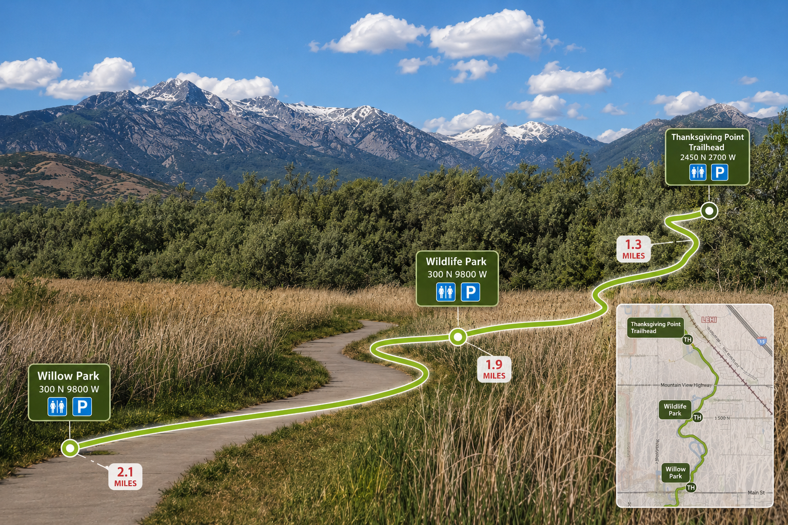
🅿 2. Thanksgiving Point Trailhead — Lehi
Near the Thanksgiving Point golf course — search "Thanksgiving Point Jordan River Trailhead" in Google Maps
Per the Daily Herald and Utah County, this is one of the most popular Lehi access points. Utah County completed major rehabilitation work on this section of the trail in spring 2025 — the pavement is freshly repaired. Convenient for residents in western and central Lehi.
Best for: Quick access from central Lehi. Shorter out-and-back rides.
🅿 3. Willow Park / Lehi Main Street
Head west on Lehi Main Street approximately 1 mile — trail crosses the road near the river
Per Utah Mountain Biking's Lehi trail guide, Willow Park sits just north of the Main Street crossing and is a shaded spot with picnic areas — a great mid-ride stop. Komoot confirms parking is available at both Willow Park and Olympic Park for this section of the trail.
Best for: Central Lehi residents. Head north to Olympic Park and the Jordan Narrows, or south toward Thanksgiving Point and Saratoga Springs.
🅿 4. 1500 North Bridge — Lehi
Take State Street north to 1500 North, turn west, drive approximately 1.5 miles to the river bridge
Utah Mountain Biking confirms there is a parking area at the river bridge. This is the northernmost Lehi access point before the trail enters the Jordan Narrows and transitions to Salt Lake County. The Lehi Free Press describes this section as less manicured and more wild — deer are a common early morning sighting here.
Best for: Riders who want to head north into the Jordan Narrows, one of the most scenic stretches of the entire trail.
🅿 5. Saratoga Springs Southern Trailhead
Near Saratoga Road, Saratoga Springs — parking lot on site, Inlet Park directly across the street
Per the Deseret News family trail guide, the Saratoga Springs end is one of the best starting points for families — flat from the first pedal stroke, with Utah Lake views and the chance of spotting pelicans on the water.
Best for: Families with young kids starting from the south end. Head north at your own pace and turn back whenever the group is ready.
⚠️ 2100 North — Currently Closed
As of April 2026, the section under 2100 N in Lehi is closed due to UDOT construction. Check udotinput.utah.gov/2100north before planning a ride through this area.
How Far Should You Go?
With young kids (under 6): Start at Saratoga Springs or Olympic Park and ride 1–3 miles, then turn back. Total: 2–6 miles round trip.
With older kids and teens: A 6–12 mile out-and-back from any Lehi access point makes a solid afternoon. Bring water.
A great starter ride: Utah Mountain Biking recommends catching the trail at Main Street and riding north to the Jordan Narrows turnaround — about 10 easy miles round trip with some of the best scenery on the Utah County section.
For serious riders: The trail connects at the Jordan Narrows to the Salt Lake County section continuing north. The full trail is nearly 50 miles one way.
What to Bring
- Water — especially on the Utah County section which has fewer water fountains than the Salt Lake County portions
- Sunscreen — Utah elevation means faster burns than you'd expect
- Downloaded map — signage can be inconsistent; the Jordan River Commission trail map or AllTrails route prevents frustrating wrong turns
- Bike helmets — essential for family rides
- Leash for dogs — required on the trail
- Watch for goatheads — puncturevine can flatten bike tires in some sections, especially late summer
Current Trail Conditions (2026)
The Utah County section is in good shape following the 2025 rehabilitation project. The section under 2100 N in Lehi is currently closed due to UDOT construction — check udotinput.utah.gov/2100north for updates.
Why This Trail Matters for Utah County Families
Utah County Public Works manager Beltran put it directly in the Daily Herald: "The trail provides not only a transportation network for those commuting to work but also a recreational amenity for our residents to walk, run, bike and enjoy some fresh air."
For families moving to Saratoga Springs or Lehi, it's one of those quality-of-life amenities people don't always know to ask about — but that ends up being a big part of why they love where they live.
As I covered in my summer events guide for Lehi and my guide to Saratoga Springs' new high school and infrastructure, the outdoor and community infrastructure in this part of Utah County is a genuine differentiator.
Quick Reference
| Details | |
|---|---|
| Length (Utah County section) | 9–10.4 miles one way |
| Surface | Fully paved asphalt |
| Difficulty | Easy — 0.1% average grade |
| Open | Year-round |
| Dogs | Welcome on leash |
| Olympic Park access | 2700 W 1600 N, Lehi UT 84043 |
| Thanksgiving Point access | Near golf course, Lehi |
| Willow Park access | West on Lehi Main St ~1 mile |
| 1500 North access | State St north to 1500 N, west to river |
| SS Trailhead | Near Saratoga Road, Saratoga Springs |
| Current closure | 2100 N — udotinput.utah.gov/2100north |
| Trail map | jordanrivercommission.gov |
Questions about life in Lehi or Saratoga Springs? Let's chat →
Frequently Asked Questions
Where do I park to access the Jordan River Trail in Lehi? There are five access points: Olympic Park at 2700 West 1600 North, Lehi UT 84043 (walk to the back of the park); the Thanksgiving Point Trailhead near the golf course; Willow Park off Lehi Main Street heading west about a mile; the 1500 North river bridge (head north on State Street to 1500 N, then west ~1.5 miles); and the Saratoga Springs southern trailhead near Saratoga Road.
What is the best access point for families with young kids? The Saratoga Springs southern trailhead and Olympic Park in Lehi are both excellent for families. Olympic Park has restrooms, a picnic pavilion, and a playground on site. The Saratoga Springs trailhead has parking and Inlet Park across the street. Both offer flat, easy trail in either direction.
How long is the Jordan River Trail in Lehi and Saratoga Springs? The Utah County portion spans approximately 9–10.4 miles one way through Lehi and Saratoga Springs. It connects northward to the Salt Lake County section which continues nearly 40 more miles to the Great Salt Lake.
Is the Jordan River Trail good for families with young kids? Yes — rated easy with an average grade of 0.1%. The entire surface is paved asphalt. Kids on balance bikes, training wheels, and scooters all do well. Dogs are welcome on leash.
Are there any closures on the Jordan River Trail in 2026? As of April 2026, the section under 2100 N in Lehi is closed due to UDOT construction. Check udotinput.utah.gov/2100north for current status. The rest of the Utah County section is open.
Can you connect to other trails from the Jordan River Trail in Lehi? Yes — at the Jordan Narrows it connects to the Salt Lake County section continuing north. The Jordan River Trail is also part of the Golden Spoke network — over 100 miles of connected paved trail between Ogden and Provo.
What wildlife might I see? Great blue herons, beavers, mule deer, and various waterfowl are commonly spotted along the Utah County section. Pelicans have been seen on Utah Lake near the Saratoga Springs trailhead.
Related reading:
- Lehi Summer 2026: Complete Guide to Events, Festivals, and Things to Do
- Eagle Mountain Summer 2026: Complete Guide to Events and Things to Do
- New High School Coming to Saratoga Springs: Everything You Need to Know
- Best Pools for Kids in Utah County 2026
- Is Utah County a Good Place to Live? An Honest Local's Guide
- Mahjong Is Having a Moment in Utah County — Our Mahjong Table
Sources: Jordan River Commission — Trail Map; Lehi City — Olympic Park official page, 2700 W 1600 N; Yelp — Jordan River Trail Lehi, Olympic Park access review, September 2025; Trailforks — Lehi–Saratoga Springs section: 10.4 miles, easy, 0.1% grade; Daily Herald — Trail Rehabilitation in Lehi, April 2025; Utah County Government — Remediation Project Nearing Completion, April 2025; Salt Lake City Public Lands — Longest paved urban trail in the US; AllTrails — Olympic Park to Jordan Narrows, goatheads/wildlife notes; AllTrails — 2100 N closure April 2026; Deseret News — Best Trails for Family Bike Rides in Utah, September 2024; Utah Mountain Biking — Lehi access points at Main Street and 1500 North; Lehi Free Press — Down by the River Side in Lehi, July 2016; Komoot — Willow Park to Olympic Park section, parking confirmed.
Written by Kat Ashby, Principal Broker and Realtor® at RootQuest Realty LLC in Saratoga Springs, Utah. Kat holds a Utah Division of Real Estate Principal Broker license (Credential #10382396-PB00) — a designation that requires demonstrated experience, additional coursework, and a separate licensing exam beyond the standard agent license. She has been actively selling in Utah County since 2020, with deep experience across Lehi, Eagle Mountain, Saratoga Springs, and the broader Wasatch Front, specializing in buyer and seller representation, new construction, and corporate relocation through Altair Global. She is fluent in English and Portuguese, earned her bachelor's degree in Psychology from Brigham Young University, and lives in the community she sells in.
